Brookings, South Dakota, USA
August 29, 2022
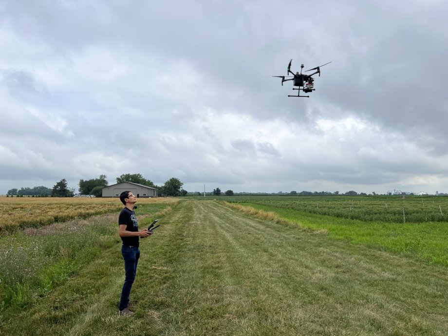
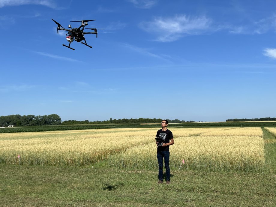 Maitiniyazi Maimaitijiang flying a drone over a crop field.
Over the last decade, agriculture research has become more and more advanced—in large part because of unmanned aerial vehicles, otherwise known as drones. At South Dakota State University, drones have become integrated into a variety of research activities but have arguably been the most impactful in agricultural research.
Maitiniyazi Maimaitijiang, an assistant professor in the Department of Geography and Geospatial Sciences, has been working in conjunction with other faculty members to conduct drone-related ag research over the last few years, specifically in relation to early diagnosis of crop water stress, nutrient deficiency, crop health and diseases—major threats to food security and crop yield estimations.

Maitiniyazi Maimaitijiang, an assistant professor in the Department of Geography and Geospatial Sciences.
“We are trying to develop robust, rapid, accurate and operational solutions and tools to detect and diagnose crop water stress, nutrient deficiency, and crop health and diseases—especially early detection,” Maimaitijiang said. “We are trying to develop some new algorithms using satellites, using drones, using artificial intelligence, using different types of information, to detect this in advance before the symptoms become visible. Because once it becomes visible, the control could be too late.”
Once the disease becomes visible on the leaf level, even spray may become useless, Maimaitijiang noted.
Previously, the traditional method of detecting crop disease was laborious and time consuming—requiring hours and hours of tediously collecting data over acres and acres of fields. Drone technology has created a more efficient—and reliable—method for detecting crop disease. While still not a perfect science, deep learning has made breakthroughs in the field of digital image processing, which combined with drone technology—has propelled ag research forward in recent years.
Maimaitijiang and Shahid Khan, a doctoral student, have spent the last few months collecting data using drones to further their research. Below is a synopsis of the ins and outs of becoming a drone pilot and a rundown of their research process.
Becoming a drone pilot
Maimaitijiang got his initial start in drones in 2015 at Saint Louis University, where he earned his Ph.D.
“I worked in the remote sensing lab there,” Maimaitijiang said. “Most of my work was drone-related stuff.”
Between 2015 and 2022, the drone industry increased substantially. In 2020, the commercial drone market was pegged at $13.44 billion, and is expected to double every two years through 2028.
The SDSU Department of Geography and Geospatial Sciences, the de facto drone experts on campus, responded to the industry’s growth and began offering drone instruction in 2017. Now, the department offers a certificate in unmanned aircraft systems, which requires 12 credit hours, and will offer an 18-credit hour minor in unmanned aircraft systems—tentatively set to start in fall 2023.
The primary class for drone instruction at SDSU is "GEOG 270, Introduction to Small Unmanned Aircraft Systems." GEOG 270 is somewhat of a “melting pot” course, with students from aviation, agriculture, precision agriculture and construction management programs, among others, all coming together to learn how to fly and operate drones. Another key course GEOG 483/583 UAS Remote Sensing trains students with multiple tools and skills for drone image processing which generates useable maps and products.
After taking that class, students have the knowledge to pass the Federal Aviation Administration’s Part 107 Remote Pilot Certificate—a requirement for commercial operation of a drone. All researchers who incorporate drones into their work must pass the FAA’s test.
Khan remembers being a little nervous before taking his FAA certification test. He had studied two to three hours a day for about a week but still wasn’t convinced he was going to pass.
“I thought it might be hard and that I might fail,” Khan said. “But I went there, took the test and it went very well. I passed and became certified.”
After getting his FAA license, Khan was able to start flying drones. But rather than fly the commercial-grade drones used during the data collection, Maimaitijiang instructed Khan to learn to fly a much more challenging drone: a DEERC D20—a $50 “mini” drone designed for kids.
“That one is actually not easy to fly,” Maimaitijiang said. “It does not have GPS or a barometer so there is no automatic hovering mode. It can be very unstable.”
Using these “hobby” drones, Khan and other doctoral students prepare to fly the commercial grade drones. After 20 hours of training, in which they practice different landings, take offs and flight paths, the students are ready for the “big leagues.”
“Once you get used to that one, it is much easier to fly these bigger (drones),” Khan said.
Flying the commercial-grade drones are surprisingly pretty straight forward, Maimaitijiang said.
“The main reason is because most of these commercial drones have very good GPS and barometer devices,” Maimaitijiang explained. “When you take off, it can automatically adjust its position and hover there, even when you take your hands off the controls.”
Drones can also be programmed to go on autonomous missions. Prior to heading out to a research field, Maimaitijiang and his students will program in a flight path for the drone.
“Prior to the flight, you need to do the mission planning,” Maimaitijiang said. “You need program in the flight height, flight speed, flight paths—all those parameters you need to define preflight and then send this information to the drone.”
Once at the field, the drone will fly itself and Maimaitijiang can focus on the data being collected. Due to FAA rules, there still needs to be someone holding the drone’s controller, however.
“We upload the mission and with just one click, it will automatically take off, collect the data and then come back,” Maimaitijiang explained.
Some drones can fly for around two hours, and others can fly for 30 minutes—it all depends on the type of drones (fixed wing or rotary drone), and also the payload and amount of equipment it is carrying. They will usually cover between 10 and 50 acres during a flight.
“That’s the main limitations of these drones,” Khan said. “You cannot cover too much area using these batteries.”
There are some restrictions that drone pilots must keep in mind. Drones are not supposed to fly over 400 feet high and, for many flight situations, requires approval from the local airport if the flight area is near. Pilots also need to have emergency plans, insurance and approval from landowners on hand.
Most drones cannot be flown while it’s raining but they can be flown during the winter, as long as it’s not too cold or too windy. For rotary drones, wind speeds often need be under 15 mph and cannot have gusts over 20 mph for safety—a challenge in South Dakota. These types of drones can’t handle extreme heat, either. For data to be collected accurately, conditions need to be favorable and very mild.
“That’s why when you’re taking the FAA test for certification, there’s a lot of weather-related questions because they really want you to be aware of the clouds, wind and everything else,” Khan said. “One thing that they specifically focus on is you need to plan accordingly to the weather. So before planning for flight at specific locations, you need to check the weather.”
While drones are absolutely necessary for data collection, they are simply a vehicle for the more important and expensive piece of research equipment: the sensors. While high-end drones needed for the type of research Maimaitijiang does can be between $5,000 and $15,000, the infrared sensors needed to collect the data can be five to 10 times more expensive.
“Certain sensors are compatible with certain drones, while others are not. The drone is just the vehicle to carry those sensors,” Khan said. “They are really like the backbone of the system.”
The hyperspectral sensors are really just very high-end cameras that collect the data in different ranges of electromagnetic spectrums, Khan said.
Collecting data
When the weather cooperates enough to fly the drone, Maimaitijiang will travel to various farms and research fields to collect data. At the fields, he will fly commercial-grade drones at various heights, which collect data using the high-performance sensors.
“When it flies over a wheat field—for example—it collects images,” Maimaitijiang said. “We use these images—now labeled as data—to train artificial intelligence machine learning models. It can then automatically detect if there is disease.”
Using this information, farmers would be able to apply a specific amount of fungicide resistance control chemical spray at specific locations (in a more efficient manner) to rid their field of disease, Maimaitijiang noted.
“We can use drone techniques to automatically get growth status, canopy height, crop health and disease level, nutrients and water stress level and predict the final yield,” Maimaitijiang said. “We just take that data (that was collected from a drone pass) and build some data drive artificial intelligence models. This model uses the data to detect those different parameters.”
The collected data from the drones is beneficial for both farmers and breeders as they are able to accelerate the plant phenotype breeding process with high efficiency, Maimaitijiang said.
Khan, who has previously had a research article published about crop yield predictions using remote sensing data from satellites, is doing similar work now, except instead of satellites, he is using drones.
“Currently, what we are doing is flying drones over different crops at different stages in the growing cycle—like early stage, into the growing stage and then at maturity,” Khan said. “We fly 10-12 times each cropping season.”
The collected data from the crops is then correlated with crop yield and other parameters, Khan said. His specific research work is looking to accurately estimate crop yield prior to harvest.
The overarching goal of Khan’s research is to make crop yields more efficient for farmers.
“Another thing is, before the harvest, (farmers) can see what’s going on in their crops,” Khan said. “So, if they need to do some intervention or if they need to make some decisions, like increasing fertilizers or something else, it can help them in the decision-making process to increase yield or control disease.”
Future uses
In the future, Khan wants to continue researching crop characteristics through drones while venturing into more disease monitoring.He is also looking to work with researchers at tribal colleges to seek out invasive species using drone technology.
As drones continue to filter more and more into the mainstream, breakthroughs will continue to happen, Maimaitijiang theorized.
“Drones have made research a lot easier,” Maimaitijiang said. “Integrated with artificial intelligence, in plant breeding, precision ag—drones are basically revolutionizing the crop scouting in those fields.”