Boulder, Colorado, USA
May 17, 2016
Agricultural intelligence company, Agribotix™, continues to expand its footprint in North America. The emerging industry leader announced today that its FarmLens™ cloud processing service will be offered via the WinField Answer Tech® agricultural technology portal.
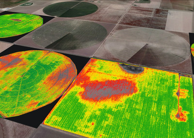
Agribotix processes and analyzes agricultural data gathered by drones via its FarmLens™ cloud-based analysis and reporting solution. The resulting intelligence, delivered in the easy-to-use formats our growers and agronomists have demanded, is applied throughout the growing season to save money. Applications include: making field scouting more efficient, monitoring stand density, and identifying areas compromised by weather events, blights, insects, other pests, or irrigation irregularities in time to treat those areas and increase yields or to deprioritize them for the season. FarmLens intelligence helps farmers increase yields, reduce input costs, and maximize profits, while reducing environmental impact.
It takes only a few minutes for a farmer or ag service provider to initiate an upload of the data captured by their drones to the FarmLens platform. Agribotix then handles all the processing and returns reports and maps with clear color contrast that makes identifying issues in the field and taking appropriate action easy and intuitive.
FarmLens reports distinguish healthy areas from those that require attention, enabling farmers to make timely interventions during the growing season. They also provide gridded management zone maps that can be used with precision equipment to tailor variable rate fertilizer, pesticide, and herbicide application. Results are returned in formats commonly used in agricultural equipment and management systems.
Jason Barton, VP of Sales for Agribotix said, "Agribotix is excited about making our FarmLens platform available to Answer Tech customers. WinField is a leader in ag technology and we've designed FarmLens exclusively to meet agricultural needs. That means fast – and getting faster – turnaround of reliable, actionable results that are more intuitive and accurate than anything else available. Agribotix is 100% focused on agriculture, and that's evident in the quality, utility, and simplicity of FarmLens software."
"Agribotix FarmLens brings specialized agricultural data and analytics to the Answer Tech® portal. Our customers can quickly process aerial imagery and get back results that they can use immediately to improve performance in the field," said James Coday, WinField Marketing Manager, Ag Technology. "The functionality and reporting designed specifically for agriculture give farmers and ag professionals a powerful, new precision tool."
Visit the Answer Tech website at https://www.answertech.com/Application-Landing-Pages/Agribotix-FarmLens for more information on the Agribotix FarmLens data processing and analytics platform.
WinField Solutions, LLC, a Land O'Lakes company, provides agricultural professionals in the US, Canada, and Mexico with proprietary and vended expertise and products, including seed and crop inputs.
About Agribotix
Founded in Boulder, Colorado, in 2013, Agribotix LLC delivers agricultural intelligence to increase yields and profits using drone-enabled technologies. All Agribotix solutions include FarmLens,™ a leading cloud-based data analysis and reporting solution for people using drones in agriculture. Outputs include agricultural intelligence maps for in-season fertilization, georeferenced reports that can be used to identify resistant weed patches and estimate coverage, stand density analysis, and specialized reporting that supports precision agriculture programs. The FarmLens solution is bundled with the Enduro™ agricultural drone system, which includes a long-range agricultural quad copter. For more information, visit www.agribotix.com or call (720) 295-3625.