|
June 18, 2001
 Satellite
imaging can now provide Australian farmers with information
about the condition of their pastures over the internet. Satellite
imaging can now provide Australian farmers with information
about the condition of their pastures over the internet.
CSIRO Livestock Industries has
developed technology that uses satellite images to measure the
amount of feed on offer in pastures and how fast it grows.
"For the first time, the results of some of this new technology
will be available to farmers over the internet" said Dr David
Henry, Project Leader at CSIRO Livestock Industries.
"At this stage, it will be available only in Western Australia.
We are launching a web site - in
collaboration with Agriculture Western Australia and the
Department of Land Administration - where the growth rate of
pastures will be presented as averages for each shire, and where
possible, the information will be updated weekly," says Dr
Henry.
"This will be a test year for us, to see how the technology
performs and to make improvements
where necessary. We will also be assessing the use of the
information by farmers," he says.
The website is the first in a suite of satellite-based pasture
management tools, which in future years will include delivering
feed-on-offer and pasture growth rate at the paddock level.
The
pasture information can assist farmers with management
decisions such as grazing rotations, feed budgeting,
fertiliser application and other 'precision agriculture'
techniques for the grazing industry.
Farmers in Western Australia are taking part in pilot
studies designed to test both the delivery of
information to farmers and how successfully the information
can be used to improve farmers'
management decisions and bottom line. |
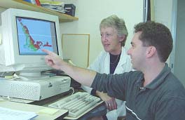 |
|
On screen maps
provide up-to-date data
for analysis and comment on growth rates. |
"We have increased our pasture
utilisation and overall fleece value by $8.93/head, and our
return per hectare, by strip grazing our young sheep and hence
increasing the stocking rate 3-fold," says Mr Roger House, a
wool producer at Muradup in south-west Western Australia.
"Other groups who will benefit from the technology include
regional shires, government, agribusiness, banking and finance,"
says Dr Henry.
"The technology can assist them in rural strategic planning,
land valuation and assessment, and
insurance."
"The accuracy and robustness of the technology is also being
tested in New South Wales, Victoria and South Australia."
The pastures from space information can be found on the Internet
at:
- www.pgr.csiro.au
- www.agric.wa.gov.au
(available from August, 2001)
More information:
Mr Anton Coppens, CSIRO Livestock Industries ph: 08 9333 6684
fax: 08 9387 8991 Email:
anton.coppens@li.csiro.au
Dr Chris Oldham, Agriculture, Western Australia ph (08) 9368
3511 fax (08) 9367 8078 Email:
coldham@agric.wa.gov.au
Mr Roger House, "Dorrington", Kojonup, WA ph: 08 9832 1031 fax:
08 9832 1045 Email:
dorrington@wn.com.au
CSIRO news release
N3602 |