Greenbelt, Maryland
May 27, 2009
 |
|
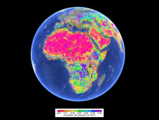
The
AMSR-E satellite instrument captured data over Africa on
April 7, 2004 from which this image of global root-zone
soil moisture was produced. The data overlays a Google
Earth map of the entire continent, with warmer colors of
pink, orange and yellow depicting lower levels of
moisture and cooler colors of green and blue and purple
indicating higher levels of moisture in the soil.
Credit: NASA and Google Earth |
| |
 |
|
The
AMSR-E instrument delivers global soil moisture
observations to combat poor data coverage in some
regions due to sparsely located ground-based sensors
like the one in this photograph. Credit: NASA JPL |
Soil moisture is essential for
seeds to germinate and for crops to grow. But record droughts
and scorching temperatures in certain parts of the globe in
recent years have caused soil to dry up, crippling crop
production. The falling food supply in some regions has forced
prices upward, pushing staple foods out of reach for millions of
poor people.
NASA researchers are using
satellite data to deliver a kind of space-based humanitarian
assistance. They are cultivating the most accurate estimates of
soil moisture – the main determinant of crop yield changes – and
improving global forecasts of how well food will grow at a time
when the world is confronting shortages.
During a presentation this week at the the Joint Assembly of the
American Geophysical Union in Toronto, NASA scientist John
Bolten described a new modeling product that uses data from the
Advanced Microwave Scanning Radiometer for EOS (AMSR-E) sensor
on NASA's Aqua satellite to improve the accuracy of West African
soil moisture. The group produced assessments of current soil
moisture conditions, or "nowcasts," and improved estimates by 5
percent over previous methods. Though seemingly small and
incremental, the increase can make a big difference in the
precision of crop forecasts, Bolten said.
The modeling innovation comes at a time when crop analysts at
agencies like the U.S. Department of Agriculture (USDA) are
working to meet the food shortage problem head on. They combine
soil moisture estimates with weather trends to produce
up-to-date forecasts of crop harvests. Those estimates help
regional and national officials prepare for and prevent food
crises.
"The USDA's estimates of global crop yields are an objective,
timely benchmark of food availability and help drive
international commodity markets," said Bolten, a physical
scientist at NASA's Goddard Space Flight Center, Greenbelt, Md.
"But crop estimates are only as good as the observations
available to drive the models."
Crop analysts must estimate root-zone soil moisture, the amount
of water beneath the surface available for plants to absorb. But
estimating the amount of water in soil has posed challenges.
Ground-level sensors for rainfall and temperature -- the two key
elements for estimating soil moisture – are often sparsely
located in the developing nations that need them the most.
Hard-to-reach terrain like mountains or desert, lack of local
cooperation as well as high maintenance costs, can lead to
sensors more than 500 miles apart.
Under a new NASA-USDA collaboration known as the Global
Agriculture Monitoring Project, Bolten and colleagues from the
USDA's Agricultural Research Service are using AMSR-E to fill
the data gaps with daily soil moisture "snapshots." Since its
launch in 2002, the instrument has "seen" through clouds, and
light vegetation like crops and grasses to detect the amount of
soil moisture beneath Earth's surface.
AMSR-E uses varying frequencies to detect the amount of emitted
electromagnetic radiation from the Earth's surface. Within the
microwave spectrum, this radiation is closely related to the
amount of water that is in the soil, allowing researchers to
remotely sense the amount of water in the soil across any
geographic landscape.
Following a test of their system over the United States,
Bolten's team tracked West African rainfall, temperature, and
model assessments of soil moisture with and without the AMSR-E
satellite sensor observations. They used West Africa as a model
because the landscape provides varying cover, from desert and
semi-arid landscape in the north to grasslands, lush forests,
and crop land to the south. Rainfall in the region is highly
variable yet sparsely monitored by ground-based sensors. They
also targeted West Africa to demonstrate the possibility for
improving the assessment of drought-caused food shortages on the
region's dense population.
"Many developing countries are relying on limited and highly
variable water resources," said Bolten. "And typically those
same regions don't have adequate ground station data or
crop-estimating agencies capable of making reliable production
forecasts."
By definition, the severity of agricultural drought is
determined by root-zone soil water content. So Bolten's
satellite-driven boost to root-zone soil moisture prediction
also directly improves drought monitoring. And Bolten says
results from AMSR-E are just a precursor to dramatic new
improvements in data and prediction accuracy researchers expect
from the Soil Moisture Active and Passive satellite, slated to
launch in 2013.
Food reserves are at their lowest level in 30 years, according
to the United Nations World Food Program, putting the world's 1
billion poorest people most at risk. Prices for wheat, rice, and
corn have more than doubled in the last 24 months, hitting
countries like Haiti, Bangladesh, and Burkina Faso the hardest.
And the U.S. is not unaffected -- drought in 2008 led to an
estimated $1.1 billion in crop losses in Texas alone.
"This advance is making it possible for us to do our job in a
more precise way," said Curt Reynolds, a crop analyst for the
USDA's Foreign Agricultural Service in Washington. "We plan to
make NASA's soil moisture information available to commodity
markets, traders, agricultural producers, and policymakers
through our Crop Explorer Web site."
by Gretchen Cook-Anderson , NASA Earth Science News Team |
|