Tucson, Arizona
April 24, 2008
|
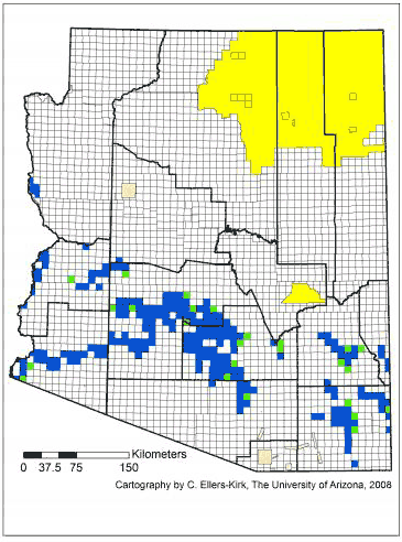
Map of
Arizona Agricultural Fields in 2005 |
 |
|
This
map shows the 2005 distribution of agricultural fields
of any crop in Arizona counties (delimited with thick
lines) and townships (delimited with thin lines). The
townships average 85.2 square kilometers (32.9 square
miles) in size. For the 261 townships with at least one
agricultural field, the average number of fields per
township was 96. Twenty-five of those townships had
between one and five fields (green); the other 236
townships had between six and 356 fields (blue). Most
land grants (pink) and Indian lands (yellow) are not
divided into townships. Mapping the distribution of
genetically engineered crops by county, or in many cases
by townships with more than five fields, would preserve
farmers' privacy. Mapped data are from the Arizona
Geographic Information Council and the Arizona Cotton
Research and Protection Council.
Credit: Cartography by C. Ellers-Kirk, The University of
Arizona, 2008. |
| |
Source:
The University of Arizona
Access to maps of biotech crops on
a county and township level will give researchers greater
ability to analyze the effects of biotech crops on wildlife,
water quality, and on pest and beneficial insects.
"Since 1996 more than a billion acres have been planted with
biotech crops in the U.S.," said Michelle Marvier of Santa Clara
University in California. "We don't really know what are the
pros and cons of this important new agricultural technology."
"People on both sides of the debate about genetically engineered
crops have been making a lot of claims," said Marvier, an
associate professor of biology and environmental studies. "One
side has been saying that biotech crops reduce insecticide use,
reduce tillage and therefore the erosion of top soil. People on
the other side say that biotech crops could hurt native
species."
The scientists' call will be published as a Policy Forum in the
April 25, 2008, issue of the journal Science. Marvier's
co-authors are Yves Carrière and Bruce Tabashnik of
The University of Arizona
in Tucson; Norman Ellstrand of the University of California at
Riverside; Paul Gepts of the University of California at Davis;
Peter Kareiva of Santa Clara University and The Nature
Conservancy; Emma Rosi-Marshall of Loyola University in Chicago;
and L. LaReesa Wolfenbarger of the University of Nebraska in
Omaha.
The article, Harvesting Data from Genetically Engineered Crops,
has a map showing the distribution of crop fields in Arizona
township by township.
Tabashnik, UA head and professor of entomology, said, "Putting
Arizona's biotech cotton on the map has allowed us to be a
leader in assessing the environmental impacts of biotech crops."
In Arizona, a unique collaboration between researchers and
farmers has made detailed crop data available to researchers at
The University of Arizona.
Tabashnik said, "It's a win-win situation. We analyze data they
collect, so they can control pests better and make more money.
It helps us obtain fundamental information about what's going on
in the field that we could never get without them."
One of the UA's analyses showed that adoption of biotech cotton
in Arizona helped to reduce insecticide use while sustaining
yields.
Carrière, a UA professor of entomology who has done many of the
analyses, said, "You have to protect the privacy of the farmers.
We've done it in Arizona, so why not do it across the country?"
To start examining those questions in other parts of the U.S.,
the team of scientists call for the government to make available
data it is already collecting.
At the present time, the team writes, the U.S. Department of
Agriculture collects data at the scale of individual farms, but
the data are only available to researchers at the scale of
entire states. Answering key questions about the environmental
impacts of genetically engineered crops requires finer spatial
resolution.
"The analyses could be about quality of water, quality of soil,
non-target effects, regional population density of pests and
economic aspects such as yield improvement," said Carrière. "The
findings could be useful to a wide range of people."
The U.S. Department of Agriculture’s National Agricultural
Statistical Service annually collects data documenting acreage
planted to various crops in all 50 states, the researchers write
in their paper. In addition, the NASS annually interviews more
than 125,000 farmers about their land use and the acreage
planted in various biotech crops.
Tabashnik said, "We're already spending the money to have these
data collected. Let's make them available in the right format
for researchers to use. It would be a relatively inexpensive
additional step with enormous scientific and public benefit." |
|